Big Bend National Park has been undergoing changes over the past
twenty years or so, but still has many features I find attractive. It's very
large (and getting larger--the Rosillos Mountains section was added to the
northern portion of the park recently), and has a spectacular range of scenery ranging from juniper covered mountains to volcanic desert badlands to deep, narrow canyons down at the river.
Major changes over the last twenty or so years include the collection
of an entrance fee (in addition to camping fees for overnight stays), the increase
in visitation
(although those who have been to Yosemite, Yellowstone, or the Grand Canyon
would scoff at this), and the increase in river travel, particularly packaged
river
expeditions. The Terlingua/Lajitas communities just west of the park have gone
through somewhat of a boom, I'm told.The essence of the park remains unchanged,
however, unless you happen to show up on one of the busiest days. If you absolutely
must
have a guaranteed camping site, I'd recommend calling the park
headquarters in advance ((915) 477-2251). (You may now, at times, reserve
some camping sites on-line through reserve.usa, but sometimes this site
doesn't seem functional.) I also strongly suggest you get a map of the park before you
go to get an idea of the layout of the park and the general geography. Trails
Illustrated puts
out an excellent map of the park complete with trails and distances as
well as all the primitive campsites, for both backpacking and car camping.
Very
generally speaking, most of the park is a desert scrub terrain, with assorted
buttes, mesas, draws, and a few mountains and
towers. Most people enter via Persimmon Gap in the north, then
approach the main information center (where you pay your fee) at the
center of the park, at the foot of the Chisos Mountains. The Chisos
reach to 7825' (Emory Peak), and are covered with juniper, oaks, and
pinyon pines. The campground in the center of the Chisos (the
Basin--look at a topo map and you'll understand why it's called that)
is the oldest developed spot in the park, and certainly the most
popular destination. It's popularity is well deserved. The Basin has
spectacular scenery, even from the campsites, and is the trailhead
for the most popular hikes. The temperatures are ten to fifteen
degrees (F) cooler here than in the lower elevations of the desert
floor. (NOTE: A recent Ranger talk has
convinced me that although the temperatures are cooler in the summer
and daytime, they're also warmer at night than the
surrounding lowlands.) Also in the Basin is a ranger
station, a small store, a lodge (sort of like a motel), and a restaurant.
Stores and gas stations have come and gone in various places in the
thirty years I've been visiting, so who knows what may be there when
you visit.
Most people want to camp at the Basin, and it's usually the first
place to fill up, so their next choice is either Rio Grande Village,
to the east, along the Rio Grande, or Cottonwood campsite, to the
southwest, also along the Rio Grande. Leaving the Basin and heading
toward Rio Grande Village, the elevation decreases (the Basin is at
5400') and the topography becomes fairly flat desert scrub again. Rio
Grande Village is not particularly attractive to me, but it does have
pay showers (which can often have an hour wait or more), and a decent
grocery store. The campground is large and has a lot of the Winnebago
type crowd. It seems to be pretty noisy there often, too. Remember, it
will be much more humid and hot here than in the Basin. If you head toward
Castolon (and Cottonwood) instead, you'll pass through some pretty severe
looking badlands,
then arrive at the
Cottonwood site which is (or was) a much more primitive site. There are
several primitive camping sites reachable by car or truck on the improved and
unimproved
roads in the park. Some of these
can be excellent sites for sunrise and sunset photography.
Hiking
This is in no way meant to be a comprehensive list of hiking trails in
the park, but just a small sample from my own experience.
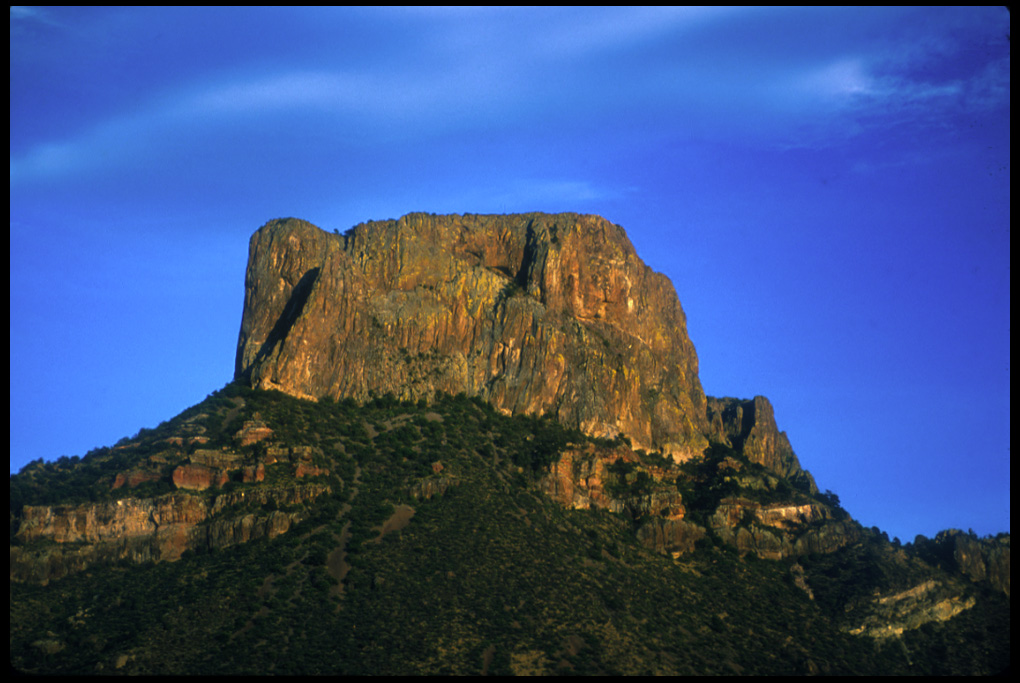
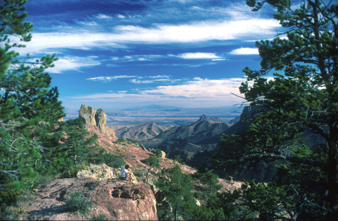
The definitive Big Bend hike is most likely the South Rim
trail (here's the GORP
trail description and map, and here's my
description of
an overnight hike along it). It's strenuous enough that most visitors don't
attempt it, but popular enough that you'll almost
always meet plenty of people along it. It runs from the trailhead in
the Basin to the South Rim of the Chisos, a rather severe bluff with a
spectacular overlook. It's about 15 miles round trip, but can vary
depending on which variation of the loop you take. There are several
designated campsites for overnight camping along the trail, but it can
be done in one day. Also along this trail is the cutoff for the
Emory Peak summit trail, the highest point in the park. (I've put a
map with GPS tracklog and Topo! generated map here.)If
you don't feel up to the South Rim, or just want to get warmed up, I'd suggest
the Lost
Mine trail. It's a modest 2.5
miles to the top, with some elevation gain, and the trailhead is near
the entrance to the Basin. I frequently use it as a sort of breaking
in hike my first day in the park, and I've had some very good light
for photography in the late afternoon from the peak.If you want to experience
hiking along the desert floor, try the
Chimneys trail. It's a level, straight hike through desert
scrub to a landmark of stone outcroppings which look sort of like,
well, chimneys. Be prepared in hot weather.
A rather remarkable thing has happened over the last decade in Big
Bend National Park; the reintroduction of the black bear (Ursus
americanus). Except, they weren't reintroduced. Apparently they've
just wandered in on their own from Mexico. In the fall of 1999, I
verified this myself when I saw a large juvenile or an adult, about 200
lbs., walking down the road just outside the Basin near the Lost Mine
Peak trailhead in early evening.
Now, one thing the Park Service has done right in Big Bend is
to institute a zero tolerance policy on garbage at the first
sign of bear. All backcountry campsites in the mountains, and even the
Basin campgrounds have bear boxes. So far this has helped keep
bear/human contact to a minimum.