Day 1-3 | Day
4 | Day 5 | Day
6 | Day 7 |
Day 8 | Day 9 | Day
10 | Day 11 | Day
12 | Day 13 | Day
14 | Day 15 | Day
16 | Day 17| Day
18 | Day 19| Day
20 | Day 21 | Epilogue
JMT Journal Day1-3
Prologue—August 17-18, 2002
I departed Austin around noon on a Friday in August.
I had with me my gear, a reservation for both a motel in Bishop, California
and a campground in Yosemite
National Park, and a wilderness permit secured several months before which
was supposed to enable me to stroll from the Happy Isles trail head in
Yosemite,
through wilderness areas in national forests and two other national parks,
and arrive at the summit of Mt. Whitney, 211 miles to the south. In addition,
I
had secured a promise from my brother to meet me at the Bishop motel, follow
me to Whitney Portal to drop my truck off, then ferry me to Yosemite.
I had been planning the trip for a couple of years, and had spent the previous
year acquiring gear, maps and knowledge that afforded me the least likelihood
of a premature exit from the trail. During the drive out west, I kept going
over trip and equipment details and fighting off the nagging feeling I had
forgotten something. (Something I'm sure every backpacker deals with.)
This was probably the first time I'd driven to El Paso since they'd increased
the speed limits; I was surprised to find even though I had left late (around
noon) I still got plenty of miles in that day. I spent the night in Las Cruces,
New Mexico. The next day I made a logistical mistake; owing to my dislike of
Interstate driving (with a capital "I") I tried a shortcut from southwestern
New Mexico to eastern Arizona. It *looked* like a shortcut on the map, but
ended
up going pretty slowly, so I probably lost some time there. I made it to Boulder
Dam by sunset, after a brief security check to make sure I wasn't going to
blow
it up. It was the first time I'd been there since I was a kid in the 1960's,
and it actually looks pretty cool—a monument to 1930's WPA engineering
and retro design.
Anyway, I spent that night in a motel in Vegas-didn't feel like gambling,
so I was pretty out of place there. Left early the next
morning, past Nellis AFB and bombing range, and then across Death Valley.
I had last visited there in 1986 when it was a mere "National Monument".
I had enjoyed that time there, but that had been in October, with highs in
the
90s.
Average Death Valley high temperatures are around 115 degree in August, and
when I passed through they had been experiencing unusually hot days, even
for
them, with highs over 120 degrees. Driving through at 9:00 a.m. I didn't
need a thermometer to tell me the temperature was already well over 100 degrees.
After a few hours, I was on 395 heading up the east side of the Sierra Nevada.
I took a quick detour at Lone Pine to the Whitney Portal trail head and
parking area, so I'd know what to expect and not have any unexpected surprises.
It
was actually pretty well packed, and I made a note of where the "overflow"
parking was.
I continued on up the highway to Bishop, found my hotel, and my brother
showed up a few hours later. I treated him to a nice steak dinner at a local
restaurant, figuring I might not have another good meal for quite some time.
We got up the next morning and drove to Yosemite, stopping at a gas station/grill
at the turnoff near Mono Lake for a pretty good cheeseburger.Got to the Crane
Flat campground, where I'd already reserved a camping spot, later that afternoon.
I spent the evening sorting out my gear and food, and we ran down to some
bear boxes at Tuolumne Meadows to stash some stuff I wouldn't need for the
first two days of the trip.
****
Begin: August 20, 2002 Crane Flat to Camp 1 (Tenaya Lake
trail junction) 54º@YVV
Got up early at the Crane Flat campground; actually, not so much "early"
as I never really got to sleep. Turns out my brother has developed into a
professional snorer. So I was up early, and loaded my pack into
the
car. Vic got me down to the parking lot near Happy Isles (4,035') in the
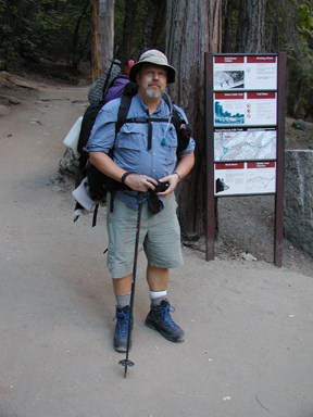
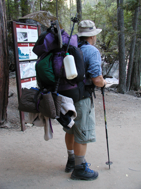
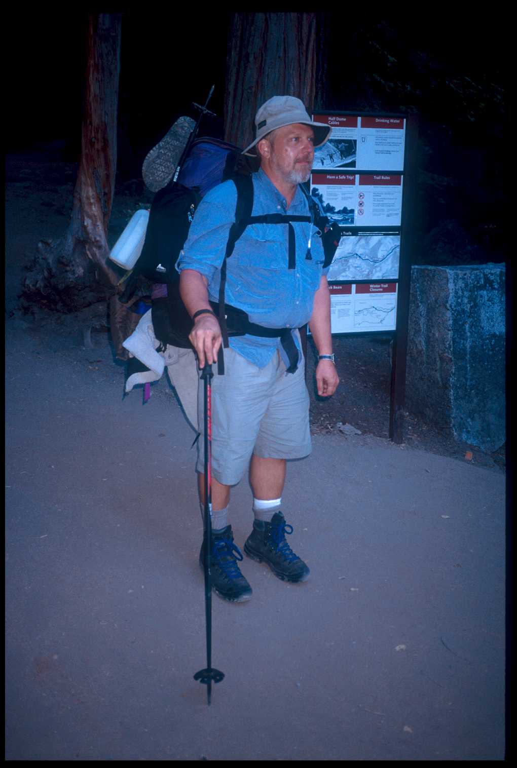
Valley at 7:00 a.m. I got out to put my boots on and strap on my pack.
For a moment
I had a sinking feeling as I staggered under the weight, probably about 60
lbs. or more, including water. Although I had stashed quite a bit of food
and other goodies ahead at Tuolumne Meadows, I still felt overloaded (for
good reason, as this
picture shows). (The Texan in me refused to believe
one could hike in the mountains without carrying
a gallon or more of water; something I would later learn to accept.) At about
7:20 we walked from the trail head up to the crossing of the Merced River,
where Vic snapped a
couple of photos of me and bade me farewell.
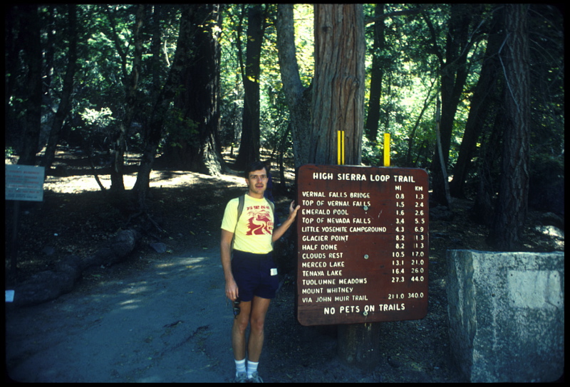
A little bit up the trail I came to the famous trail head/mileage sign,
the one that lists trail distances including "Mt. Whitney - 210 miles." I
reflected on the fact that I had already been in this spot,
some
sixteen years previous,
when my brother (shown here) and I had hiked to Nevada Falls. The trail
actually is split here. One track, the "Mist Trail," ascends steeply up the
side of the cascading Merced River, hugging close to the sides of the canyon
and waterfalls
on
the
way up. In fact when the water is high the spray from the falls will soak you.
The other track, the John Muir Trail proper, swings a bit to the south and
is
a more gradual ascent to Nevada Falls, where it meets the Mist Trail again.
In 1986 we had gone for about a half mile down the JMT from Nevada Falls in
order to get a better view of the falls. As we had returned to the falls, Victor
said, "See, if we keep on going
on this trail, you know where we end up? The summit of Mt. Whitney, over 200
miles away." I had been impressed with that
at the time, imagining all the aspects of (what seemed) an immensely long hike.
So now, in 2002, I continued up the John Muir Trail on the way to Nevada Falls.
The weather was clear and cool, perfect for hiking uphill. I met a couple of
hikers along the way, some passed me and I passed some. About a mile short of
the falls I had a deja vu experience as I remembered the same view from years
before. I got to Nevada Falls (~6,000') at 9:30, which surprised me. I had thought
it would take longer. I had climbed about 2,000' in 3.4 miles in about two hours.
Considering the full pack and my out of shape condition, I was ahead of schedule.
Hubris.
After a break at the falls, I started on into uncharted territory. Through
Little Yosemite Valley, mostly flat trail, and then up again out of the Valley.
This began to get painful. Although the trail junction to Half Dome was only
about a mile ahead, the climb was steep (about 1,000') and my feet began to
get sore. I stopped for several rests. Although I had realized all along that
the first couple of days would be the most difficult, I still was in a dark
mood as I struggled up the trail. A Ranger came the opposite way, and we chatted
briefly. I was curious about water and camping ahead and he mentioned good
camping
at a trail junction near a creek not too far away. He looked somewhat pained
when he asked tentatively, "You hanging your food?" "No, I've got a canister
in my pack." An obvious look of relief showed on his face as he related the
story of bear depredations on a couple's food the night before. He told
me it
was virtually impossible to get by with hanging food around there.
I got to the Half Dome trail junction around noon. Half Dome seemed to be the
destination of most of the hikers I'd seen so far. A little later I stopped
at the Cloud's Rest junction, where there was some decent camping available.
I considered stopping because I was tired and sore, but calculated that it would
make arriving at Tuolumne Meadows the following day next to impossible. I determined
to try to get to the Sunrise camp, at Long Meadow, about seven miles away.
The trail plunged into rather deep forest at this point, basically following
Sunrise Creek and ascending (of course!) another thousand feet. At yet another
break a mile or so up the trail, a few other JMT thru-hikers stopped and chatted.
One was on his way north, nearly finished. Another southbounder was trying
to
finish in twelve days, had just gotten off the plane from Virginia, and was
obviously pushing hard. It didn't sound like there were a lot of camping choices
before Sunrise, so I decided to camp at the first promising site I found.
This turned out to be an area near the Tenaya Lake trail junction. At the
junction, I looked around and spied a flat clearing a couple of hundred
yards
away. I made for the flat spot and took off my pack. Here, I began to figure
out what would eventually become my nightly routine. The clearing
was rather
large and very flat; in fact, it looked almost as if it had been bulldozed
(it hadn't of course). Scattered throughout the flat sandy area were some
large
smooth granite boulders, suitable for sitting on. I took off some of my sweat-soaked
clothes and laid them on the boulders to dry. Then I took my boots off--oh,
my! The pleasure of taking one's boots off after a very hard, long day of
backpacking is something not taken lightly. In fact the ecstatic afterglow
after removing 1) pack then 2) boots is usually enjoyed in a mindless, motionless
stupor, lasting up to a half-hour (depending on one's fitness and soreness
levels).
It was only 3:15 p.m. and it's possible I could have made it all the way
to Sunrise Camp before, or just at, dark. But I knew for a fact it would
have
been pure misery. I figured I'd gone just under nine miles, about 8.7 according
to a sign nearby. That meant day two would have to be about fifteen miles
in order to reach Tuolumne Meadows.
Surveying my little kingdom from my little stuporific throne, I noticed
that among the large trees surrounding the area, one in particular had been
dead
a few years, and was listing at an angle less than alarming but more than
enough to merit concern. (I have to digress here: About an hour previous
as
I was hiking along, I had heard a strange, loud noise, which seemed to come
out of nowhere. As the noise culminated in an earth-shaking *whoomp* I realized
it was a tree falling. I never saw it, but I sure did remember it.) Anyway,
I calculated various free-fall paths for this "widow maker" and moved my
sleeping bag accordingly. As I poked around the area, I found a few indications
this
campsite had frequently been used before: an old pair of spectacle frames,
the wrapper from a band-aid. Also, I looked around for potential bear-hang
trees. Not that I needed one with my canister (bear can), but just out of
curiosity. I spied a pair of trees at the edge of the clearing that seemed
ideally suited for a bear hang.
After a dinner of just gorp (I was not in the mood to cook) I had to figure
where to stow my bear can. At first I thought I'd want it near my sleeping
bag, but then one imagines mean old Mr. Bear stomping on top of me on his
way to the prize. So I put it under a tree, actually more of a clump of bushes,
about thirty yards away. I propped it up against some deadwood. (All of the
literature warns of letting your canister roll away after a bear-swipe.) Not
long after determining my can was safe, and treating a hot spot on my left
heel with a "blister block" bandage, I popped a couple of pain pills
(I was very sore) and tucked myself into bed. I put my Yaschica camera in
my boot near my head, because I anticipated a good chance at night-time wildlife.
Hey, this is Yosemite with all the "problem" bears, right?
Well, as it turned out, the bears had read the literature. I had a hard
time getting to sleep. The moon was obscenely full, and with the clear sky
the
area was brightly lit and the glare was in my face. Also, I was a bit apprehensive
about nocturnal visitors. Every pine cone falling or bird noise made me
sit
up with a start. Finally, I began to drift off to sleep around midnight.
And just at that time came a crashing sound from directly behind me. A loud
noise,
so loud at first I thought it was a human because it was marching so directly
into my campsite and so without care for the noise he made. I sat up and
turned
around, and saw a (as we say in Texas) "big ol' bear come out the woods",
marching to the opposite end of my campsite. I said "hey!" loudly,
and fished out my flashlight, but he just looked my way a briefly then
went
on to the trees I had earlier pegged as possible bear hang trees. I guess
they were, because he spent some time looking up at them—I guess
he was disappointed I had nothing hung there. I yelled at him again, and
this
time he took off around the perimeter of my site toward my bear canister,
which took him about twenty feet from the foot of my sleeping bag. I pulled
my camera out and snapped a picture. The flash went off, and I hoped I had
caught him (obviously
not). He went by my bear can, and was gone.
8/20 Camp 1 (near Tenaya Lake junction) to Tuolumne Meadows
60º@TUM
24º@TUM
I was eating my dehydrated scrambled eggs breakfast by 6:30 and was out
of camp by 7:00 a.m. It was pretty chilly; I figured well below freezing.
(I later found out it was 24° at Tuolumne Meadows.) I started with heavy over
garments and a heavy hat, but fairly quickly stripped down to lighter gear
as the
sun
and
temperature
rose.
The
trail
climbed pretty
steadily towards the Sunrise High Sierra Camp and I was glad I had waited
until
today to tackle it.
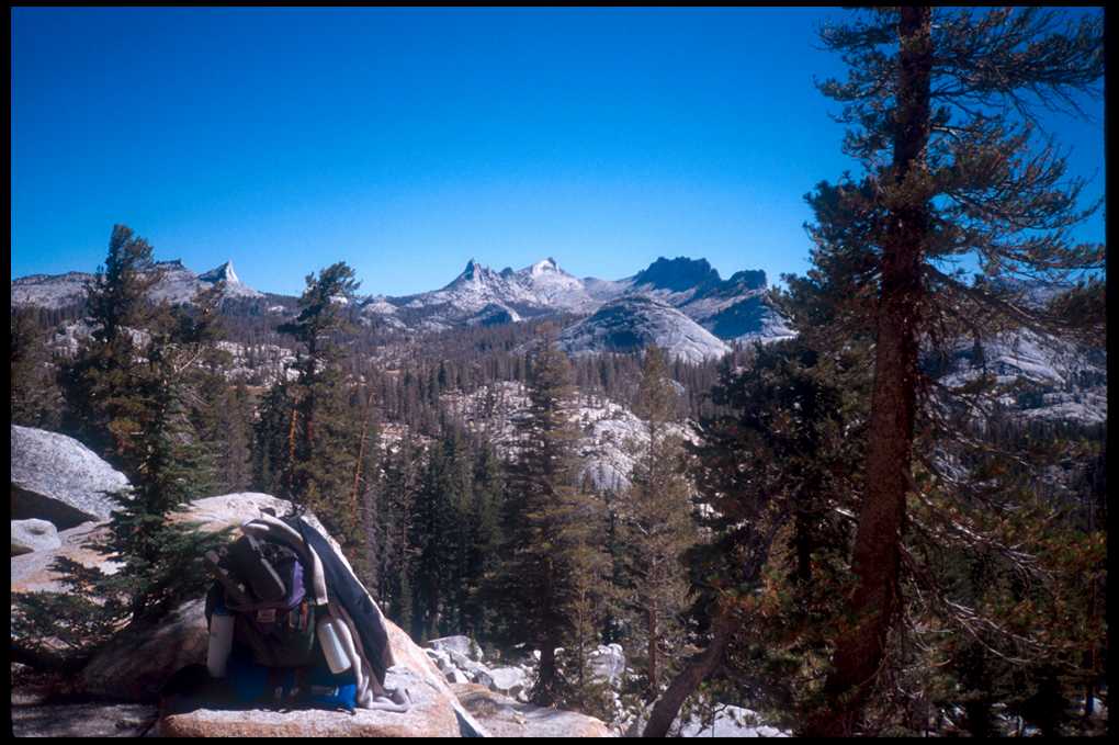
I was happy to take a break along the east-facing slope of Sunrise Mountain,
taking off my pack and snapping several
pictures of the canyon and mountains to the east. Another fellow came by and we chatted for a while; he had also
started in the Valley but was only going as far as Red's Meadow on this excursion,
although he planned to complete the JMT in future stages. I would meet up
with "Red" several more times before Red's Meadow six days hence. While discussing
trail distances and elevations, he pulled out a spreadsheet he had made up
in advance which had all the trail mileages and elevations-I thought it a
bit overkill, as I could retrieve the same data from my guidebooks and maps.
Later on in the hike, however, I came to realize that it would have saved
me a lot of effort to have done the same. Instead, I ended up spending time
each night calculating those figures for the next stretch of trail and writing
them down on the back of my maps, since I didn't want to get the book out
of my pack every time I needed that information.
A couple of miles further along the trail, although the map told me Sunrise
High Camp (and water) should be near, I nevertheless dropped down to a small
stream to get more water. I was getting thirsty (had camped at a dry site
the night before) and wasn't exactly sure when I'd end up getting to more water. As
I was pumping my filter, a hiker came by the other direction and informed
me the High Camp was just a half mile or so ahead, with plenty of water.
I thanked him, and continued on, burdened by a bit more water weight. Somewhere
along here I misstepped, I slipped, and with the extra weight of my pack
I fell very hard. I banged my right knee upon a granite boulder on the side
of the trail, and opened up quite a gash.
I was starting to get a bit discouraged. I doctored the knee the best I
could and stuck a bandage on it. I was tired already even though it wasn't
yet noon. I was sore, and now my knee was bleeding and my pack felt heavy
and gee whiz, I wasn't even to Sunrise Camp yet which was ten miles away
from my ultimate destination, Tuolumne Meadows. I toyed briefly with the
temptation of staying that night somewhere short of Tuolumne, but nixed that
idea because I wasn't carrying food for the extra night. I had stashed most
of my supplies in a bear box near Tuolumne Meadows, so making it in two days
was pretty much required of me.
Finally, I reached the top of a large meadow. I could see some structures
on the other side, so I made my way there. This had to be Sunrise Camp, but
the sign was a bit confusing and I couldn't tell where exactly the trail
led; it seemed to just climb into some rocks and go through a few sites where
there were people camping. I wandered through a site where a couple of guys
were camped, and asked where the water was: They pointed "over there" and
indicated there was a faucet. I tried to go "over there" but couldn't
find the trail through the boulders and came back and asked again. They showed
me more carefully, and one of them asked me, "Now, where are
you going?" To Whitney, at the end of the JMT, I replied. "By yourself?"
Yeah. I was a bit ticked at this, but realized where he was coming from.
He was looking at my knee, which had a few red rivulets streaming down to
my ankle. I obviously looked tired and a bit frustrated, and now couldn't
even find my way to a water faucet. They looked at each other with a knowing
look: I'm sure they saw a huge "T" for "Trail newbie" emblazoned upon my
forehead.
I ignored the skepticism, and made my way to the faucet, where I unloaded
my pack and spent some time doctoring and cleaning my knee. After a while,
as I walked around the place a bit, I came upon Red enjoying his lunch. We
chatted a bit, he offered some encouragement, and I loaded up and began the
leg to Tuolumne. Leaving Sunrise Camp, I made good time for a while because
the trail winds through a very long meadow (named "Long Meadow"). I passed
a couple of women leading a horse packing outfit full of goods for Sunrise
Camp. After leaving the meadow, the trail climbed to wind around the side
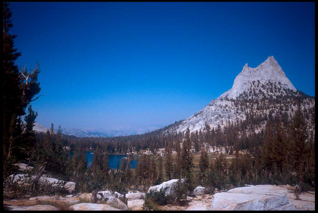
of Tressider Peak, which beat me up a bit. I finally made the rise there,
then passed Cathedral
Peak and Cathedral Lakes. It was beautiful, and I was
thinking it was all downhill from there to Tuolumne.
Well, it didn't seem like it. Where the map indicated (or I thought indicated)
long gradual descent was actually a continuing series of ascents followed
by descents followed by ascents. They weren't that steep, nor that long.
But for my second full day of hiking they were enough to make me miserable.
Add to that the fact that it was getting rather hot, and add to that the
fact that the pack train I had passed back in Long Meadow had now passed
me once, stopped for water, then passed me again. Pack trains aren't fun
to pass or be passed by; they stink and you end up covered with dust.
But finally I got to a sign pointing to the Tuolumne Meadows visitor center.
I thought that from this point the trail would run roughly parallel to the
road, and level, until it reached the campground. Wrong again; it had to
go up a few more ascent/descents, hills that I wouldn't even give a second
thought to in later days but which were killing me today, my second full
day of hiking. Sometime after 5:00 p.m. I arrived at the edge of the campground.
Unfortunately, the signs at the campground aren't designed for folks arriving
from the backcountry, so I wandered around lost for a while longer, grumbling
until I ran into a camp host who gave me a campground map. The map showed
a "backpacker's campsite" designated by a cloud shape, somewhere beneath
the rest room. I hiked a few hundred yards more, found the restroom, went
below it and saw a handful of tents set up there deep in the woods. Hmm,
I thought, not much of a campsite, but I took off my pack and boots and laid
my bag out, then went off to reconnoiter and see about getting my resupply.
A couple of days earlier I had left most of my food and a lot of the rest
of my gear in a bear box there in Tuolumne Meadows at the "Silver Springs"
trail head. I would have to pick that up later and then sort out some of
the food and gear. As I wandered around, I began to realize that where I
was
camped was not the actual backpacker's campground but a "bootleg" one;
one where hikers who didn't want to pay the nominal camping fee would camp.
I
located the real site, which was much nicer with tables. The tables would
come in handy when I was ready to sort my gear and food from my cache, so
I grabbed my stuff and began to tote it to the officially consecrated backpacker's
campsite. As I walked, I came upon a young French couple who asked about
the campsite. I told them and they came with me to the backpacker's campsite
while we talked about hiking. They had already spent one night in the backcountry,
and were going to do a multi-day trip and he was a bit concerned that he
hadn't enough food, and that they had gotten cold the previous night.
I staked out my site in the campground, paid my fee, and decided to go get
my cached gear. As I walked down the campground drive, it really hit me how
many people were there and how much noise and activity there was. Cars were
lined up at the entrance/permit station to the campground, and for the couple
of hundred yards I walked along the highway cars buzzed constantly. I crossed
the highway, found the bear box and my goods inside untouched, and returned
to my campsite where I put the goodies in the bear box for later division.
But now was time (it was getting near 8:00 p.m.) for some hedonistic pleasures.
I returned to the highway and walked a bit to the Tuolumne Meadows store.
The place was a beehive of activity—people, parents and kids streaming in
and out, rock climbers hanging out in front waiting for the shuttle, novice
backpackers in the store picking up items they'd forgotten or had broken
(the store is quite well stocked with backpacking gear).
I had a craving that wouldn't quit, so I got a bag of nacho flavored Doritos,
and looked everywhere for a quart of chocolate milk but could only find "low-fat"
chocolate milk. Great. California strikes again, probably in the guise of
some northern California "anti-fat" proposition. Disgruntled somewhat,
I went to the counter to check out (somewhat abashed at my two-day funkiness)
and mentioned to the nice girl behind the counter my disappointment in the
lack of fat-full chocolate milk. "Oh, we've got that," she said
and disappeared behind the cooler and returned with a quart of real chocolate
milk. Despite
being tiny and attractive and obviously Californian, she displayed not one
whit of disapproval of my choice. I went outside to a picnic table and consumed
the
food and
drink
with gusto and finally began to forget my sore feet, aching bones, and general
fatigue. Walking back to camp, I passed the "Ranger talk" at the
amphitheater and saw huge flames leap up. I think the topic was "Forest
Fires." After
a brief time checking maps (but mainly relaxing and resting my feet), I tucked
myself into my sleeping bag and nodded off listening to the two women camped
nearby read selections from a novel to each other. I had done almost fifteen
miles that day.
I awoke the next morning, made some coffee, and immediately began sorting
out my goods. I had already started the night before, and this morning was
just a confirmation of the previous evening's checklist. I chunked out a
bunch of coffee, instant oatmeal, and some other food; I ripped out not only
the
covers
of
my "John
Muir Trail Guide" but
also the pages which focused on the south to north trip. I tossed anything
from my pack, and from my cached goods, which seemed in any way excessive.
After the pain of the previous two days I knew this was only reasonable.
Sometime in the morning the young Frenchman came by to chat and bid adieu;
I offered him the leavings in the bear box, which now included coffee and
instant oatmeal and a few other food goodies. He refused the coffee (maybe
he wasn't really French?) but gratefully accepted the oatmeal. I wished him
well, and never saw him again.
 Finally,
around 10:00 a.m., I got on the trail. Quite a bit of traffic near the campground,
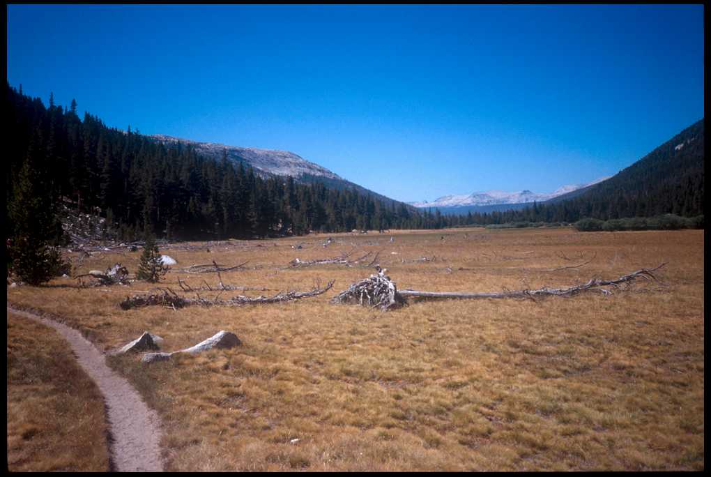
but as I headed up Lyell
Canyon, it began to spread out.
I guess the name "Canyon" had given me the impression this section
of trail would be in some sort of deep valley, but actually it was a gorgeous
wide
meadow the entire way. I snapped a few pictures, and I passed and was passed
by several groups of varying size and of varying age. One or two pack trains.
Some folks
had
little
more
than a water bottle, and I realized I was still quite close to the Tuolumne
Meadows trail head. Around 3:00 p.m. I looked ahead and saw
Donohue Pass;
I didn't feel like searching around for some potentially iffy campsites.
The guidebook indicated that where I was, the head of Lyell Canyon, was a
very popular camping area (although completely infested with
Finally,
around 10:00 a.m., I got on the trail. Quite a bit of traffic near the campground,
but as I headed up Lyell
Canyon, it began to spread out.
I guess the name "Canyon" had given me the impression this section
of trail would be in some sort of deep valley, but actually it was a gorgeous
wide
meadow the entire way. I snapped a few pictures, and I passed and was passed
by several groups of varying size and of varying age. One or two pack trains.
Some folks
had
little
more
than a water bottle, and I realized I was still quite close to the Tuolumne
Meadows trail head. Around 3:00 p.m. I looked ahead and saw
Donohue Pass;
I didn't feel like searching around for some potentially iffy campsites.
The guidebook indicated that where I was, the head of Lyell Canyon, was a
very popular camping area (although completely infested with  "marauding
bears.")
Right at the foot of the beginning of the ascent up Donohue Pass I found
(with some difficulty) a crossing of Lyell Fork and slogged my way to the
far (East)
side of the meadow. I began to find good campsites, but unfortunately they
had all been used and overused by horse outfits. I finally picked one, with
a somewhat elaborate "kitchen" area set up about a hundred feet
from where I threw my sleeping bag down. Obviously a pack train site, heavily
used; the horse crap was everywhere. I was a bit disgusted by that, and by
the fact that horse crap was lining the ad hoc trail to the meadow stream
where I got my water. But anyway I pump/filtered about 2.5 liters and made
my way back to my campsite.
"marauding
bears.")
Right at the foot of the beginning of the ascent up Donohue Pass I found
(with some difficulty) a crossing of Lyell Fork and slogged my way to the
far (East)
side of the meadow. I began to find good campsites, but unfortunately they
had all been used and overused by horse outfits. I finally picked one, with
a somewhat elaborate "kitchen" area set up about a hundred feet
from where I threw my sleeping bag down. Obviously a pack train site, heavily
used; the horse crap was everywhere. I was a bit disgusted by that, and by
the fact that horse crap was lining the ad hoc trail to the meadow stream
where I got my water. But anyway I pump/filtered about 2.5 liters and made
my way back to my campsite.
This would become pretty standard operating procedure—pumping about
2.5 liters at camp. You didn't want to have to go fetch more after you'd
made camp, and you wanted all you could possibly need for dinner, cleaning
up,
nighttime drinks and breakfast. Usually the last thing you'd do in the morning
before hitting the trail was to fill up your water bottles.
I got my water, set up my kitchen, and after eating dinner (which
most likely was beef stroganoff, since 90% of my dinners were stroganoff)
proceeded to consider the bear situation. (Something else which would become
standard campsite procedure.) I had some degree of concern, led primarily
by the fact that the guidebooks and web sites had all referred to Lyell Canyon
as one of the worst spots in Yosemite for bear raids at night. That's why
I had originally planned to camp well beyond the meadow and up closer to
Donohue Pass that night, but owing to my relatively late start out of Tuolumne
and to the fact I wasn't sure I could pick a campsite up on the valley side
towards the pass, I chose to stop where I did.
So being careful to load all my smellables and food in my bear canister,
and keeping my canister well away from my sleeping bag, I got into my bag,
watched the sun set, made some notes for the next leg of the journey and
read for a while, then tried to go to sleep. (I had noticed another hiker
pass my site around 6:00 and take a site a hundred yards or so away.) But
I had a hard time sleeping; due to the absolute stillness, the incredibly
bright full moon (I ended up sleeping with my pile hat pulled over my eyes),
and a nagging worry about the bears I only got a few hours sleep that night.
page last modified:
