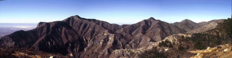
Category Archives: Backpacking

TR-Grand Canyon Backpacking January 2011

(There is a separate Trip Report for the car camping on that trip here.)

Gear, Lessons learned

Route

South Kaibab-Bright Angel Campground-Bright Angel Trail

  • 1/10/2011 (10:41 a.m.1) South Kaibab Trailhead->Bright Angel CG (4:15 p.m.)
  • 1/11/2021 Bright Angel CG (9:39 a.m.) to Grand Canyon Village (5:27 p.m.) via Bright Angel Trail

Locations/Elevations Mileages

South Kaibab Trail

Location2ElevationDistance
South Kaibab Trailhead7260′start
Cedar Ridge 6120′1.5 miles
Skeleton Point5220′3.0 miles
Tipoff4000′4.4 miles
Bright Angel Campground2480′7.0 miles

Bright Angel Trail

Location3ElevationDistance
Bright Angel Campground2480′start
River Resthouse2480′1.8 miles
Havasupai* Gardens3800′5.0 miles
Three-Mile Resthouse4748′6.5 miles
Mile-and-a-Half Resthouse5729′8.0 miles
Bright Angel Trailhead6860′9.5 miles
*Formerly Indian Gardens

Planning

While at the Grand Canyon Visitor Center at the end of 2007, I’d overheard a couple discussing with a NPS ranger backcountry permits for the Bright Angel site, at the bottom of the canyon near Phantom Ranch. I made a mental note to consider this in the near future. It’s a popular overnight and back hike; some folks pay $$ for the indoors at Phantom Ranch or a cabin but I was only interested in the backcountry sites. (My parents had hiked down and stayed at a cabin in 1978.) Aside from New Year’s Eve, there were almost always walkup available permits for Bright Angel this time of year. I made a mental note to come back soon for an overnight hike to the bottom and back. I returned for this trip in January of 2011.

Continue reading TR-Grand Canyon Backpacking January 2011

TR-Backpack-Colorado-Weminuche-September 2024

Backpacking in Weminuche Wilderness, then AirBnB in Cortez, CO

Gear, Lessons learned

Locations/Elevations Mileages

    • Bright Angel Trailhead (6860 ft / 2093 m) to:
    • Mile-and-a-Half Resthouse (5729 ft / 1748 m) Three-Mile Resthouse (4748 ft / 144 9m) Havasupai Gardens (3800 ft / 1160m) River Resthouse (2480 ft / 756 m) Bright Angel Campground (2480 ft / 756 m) 1.5 mi (2.4 km)
    • 3.0 mi (4.8 km)
    • 4.5 mi (7.2 km)
    • 7.7 mi (12.4 km)
    • 9.5 mi (15.3 km)

Trip Report

Planning

I decided I wanted to revisit a couple of backpacking trips I’d made years ago, partly because a lot of my earlier trip had been obscured by clouds and fog, and partly just to get out to a not too crowded part of the San Juans again. I would visit an area where I’d camped and backpacked going back almost forty years, the San Juan mountains and the Weminuche Wilderness. I first visited the San Juans on a long trip in 1986, car camping at Vallecito campground on the western side of the wilderness area, based on a suggestion from my parents. I returned for a couple of backpacking trips in the 1990s, in the Williams Creek area which is about thirty miles north of Pagosa Springs on USFS roads.

Continue reading TR-Backpack-Colorado-Weminuche-September 2024

TR-GUMO Pine Springs/Guad. Peak; Dog Canyon/Marcus backpack-February 2022

Took a trip out to Guadalupe Mountains National Park last week. I’d reserved Sunday and Monday nights at Pine Spring, Tuesday/Wednesday/Thursday nights at Dog Canyon. I intended on climbing Guadalupe Peak again Monday, then I was planning on a backcountry stay on Wednesday night, possibly at Blue Ridge (as discussed here; https://bigbendchat.com/tentative-plan-for-one-night-backpack-dog-canyon-b-t18146.html).

I’d been getting in pretty good shape over the past six months, doing cardio, hiking, and most recently hiking with a pack to start conditioning myself for backpacking. But I had an unexpected trip to take my 89-year old mother to California to meet her new great-granddaughter from New Zealand who was visiting family in Berkeley…but I digress. Bottom line is I was out for a week, then home for only a couple of days before leaving on my trip.

I left Austin around 4 pm arriving Ozona around 8 pm. I began this habit of breaking up the drive to GUMO a few years ago; gives me plenty of time to pack, take care of chores, and hardly feels like any time at all for the first day. And then it’s nice to get to my campsite early enough to where I don’t have to rush to beat sundown (especially in Winter). I got to GUMO just before 1:00–oops, Noon Mountain time; went to the visitor center to make sure I didn’t have to check in or anything (got that Senior Pass heh heh, and had already booked the camping) and wanted to confirm I could get my Wednesday night backcountry permit here on Tuesday morning as I left (I could).

Continue reading TR-GUMO Pine Springs/Guad. Peak; Dog Canyon/Marcus backpack-February 2022

TR-Big Bend NP Backpack South Rim Feb/March 1999

This is a trip report copied almost verbatim from what I wrote in 2000.

I took this trip on what I figured to be the last non-busy week before Spring Break; however, it was already getting crowded in the campsites (the Basin was full). I had arrived the night before around midnight; seeing that the other campsites were full I simply napped in the cab of my truck. It was fairly chilly, probably around 35-40, so I bundled up pretty well. I did see a coyote exploring the trash cans once early in the morning.

  • Trail distances for Pinnacles Trail to South Rim, return
  • via Laguna Meadows (from Basin trailhead): 
  • 3.5 miles to Emory Peak trail 
  • 4.5 miles to Boot Canyon campsites 
  • 4.8 miles to Boot Spring 
  • 5.3 miles to Southeast Rim Trail jct. 
  • 6.3 miles to Southeast Rim Trail jct. at the South Rim 
  • 8.0 miles to Colima trail jct. 
  • 8.8 miles to Blue Cr. trail jct. 
  • 12.1 miles to Basin trailhead


A bit after sunrise I went on into the Chisos Mountains to the Basin and the ranger HQ to get a backcountry permit. The nice older couple behind the counter, apparently camp hosts, pulled out a notebook with photos of the various campsites in the backcountry to help me to determine where I would go. Seeing the full campsite status, I was more concerned with getting away from crowds than a scenic site, but finally decided on Boot Canyon #4 and SW #3 just off the South Rim.

Continue reading TR-Big Bend NP Backpack South Rim Feb/March 1999

TR-Backpack-GUMO Shumard 11/16/2017

Gaiamaps link

Tracklog out to Shumard Backcountry site

CalTopo map

I spent most of a week in mid-November (2017) at Guadalupe Mountains National Park (GUMO). Camped 4 days/nights; at Pine Spring CG and in the middle an out/back overnight to the Shumard Canyon backcountry site. I don’t have a *lot* of info to add; i’ve done the El Cap/Overlook trail several times over the decades so didn’t take many photos. I had never done the Shumard Canyon stretch before so this was all new to me. It turned out to be quite challenging due to the trail conditions, and I took very few pics (even though i’d intended to do some night photography). That happens. Continue reading TR-Backpack-GUMO Shumard 11/16/2017

JMT Epilogue

June 15, 2003 Updated February 13, 2025

Lookng back almost a year after my trip I can think of several things I’d do differently, several things that worked perfectly, and maybe a few things I wished I’d known before I went on my trip.

Looking back some twenty years later, I have some thoughts on my thoughts as recorded at the time.

As far as “things I’d do differently” I can think of a few. For one, I’d hike later into the day if I didn’t feel too tired. I was so paranoid about getting caught at dark in an area with no camping that I stopped too early a few times, especially early in the trip. As it turned out, there were few places where one couldn’t camp, especially if you had water.

I suggest you keep a list of passes, trailheads, trail junctions, potential campsites, with mileages and elevations handy. I should have made a spreadsheet up with all that information before hand. As it was, I ended up making a list out on the back of my maps at night. Wish I would have done it before the trip.

As far as food is concerned, I already knew I enjoyed a rather bland diet and I wouldn’t need too much variety. Well, it turned out I needed even less than I anticipated. I had freeze-dried scambled eggs with bacon pieces and hot chocolate nearly every morning, and I would have been happy to have that every morning. My vacuum-packed tortillas and bulk-purchased but home vacuum packed beef stroganoff was excellent. I looked forward to it every night. In fact, here’s my supper routine almost every night: As soon as I halted, and had my pack off and my bag/bivy spread out, I’d take my sweaty day clothes off and put on my heavy fleece long johns and pile jacket and hat. It was usually only mildly cool, but it helped retain a lot of energy which was needed as soon as the sun went down. I’d then start boiling water; usually only took about three minutes. Then I’d measure out about a half-cup of freeze-dried stroganoff (yum!) into my cup and add the hot water to it. Then I’d place the cup inside a loosely sealed large baggie for a few minutes to “reconstitute.” Meanwhile, I’d put 1/4 cup of instant potatoes, some bacon pieces, and a dollop of margarine in my other cup. Now I’d add hot water to it and I’d immediately have a hot, starchy side dish. After the potatoes, I’d eat the stroganoff, and use the potato cup for my luxury-a cold glass of milk. Well, actually a cold cup of Milkman—an instant milk powder “with the kiss of cream.” This stuff is much better than Carnation powdered milk.

I still basically follow this routine or something similar. Only thing I might do differently is bring some Gu gels or something like that.

I brought too many heavy-duty cold weather clothes. I wore my expedition weight polarfleece every night as soon as I got off the trail, like sweat pants, but I had litle need for the other long johns.

I really wish I’d had a better place to keep my water bottles in my backpack. That includes having a place to store the water bladder.

In 2002 I was using a Gregory pack purchased in 1985. Modern-day (ca. 2022) packs have all integrated hydration systems into their design.

Gadgets

Photos/Camera

I brought a Yashica T4 in 2002 a pocket 35mm film camera. Digital was available but totally impractical for a long distance hike at that time. Four rolls of Kodak Ecktachrome slide film, so I was limited to only 100 images for the entire three week hike. I husbanded my exposures carefully; one regret is taking too many photos at the summit of Mt. Whitney, and not enough the evening before, at the camp site near Trail Crest. And no photos after Whitney! Or at the conclusion at Whitney Portal; Todd and I got a big pizza there.

GPS/Navigation

I had a fairly new, what seemed at the time tiny pocket GPS receiver, a Garmin eTrex Legend. What I didn’t really understand was how to load digital maps so I basically used it to pinpoint where I was on the Tom Harrison maps (hardcopies obviously).